Bli med på tur til laboratoriet under isen
Skjer det noe fortsatt i subglasiale laboratoriet? Ja, det gjør det, og en oppdatering kommer snart. Men først, et innlegg fra en student som var med i laboratoriet og på breen sommer 2016.
Summer Maintenance Fieldwork at the Svartisen Subglacial Laboratory
Written by Paul Weber, PhD student in glaciology, Intern at NVE April-June 2016 and 2017
"Drawing a deep breath they passed inside. [...] They walked as it were in a black vapour wrought of veritable darkness itself that, as it was breathed, brought blindness not only to the eyes but to the mind, so that even the memory of colours and of forms and of any light faded out of thought. Night always had been, and always would be, and night was all."—The Lord of the Rings, J. R. R. Tolkien
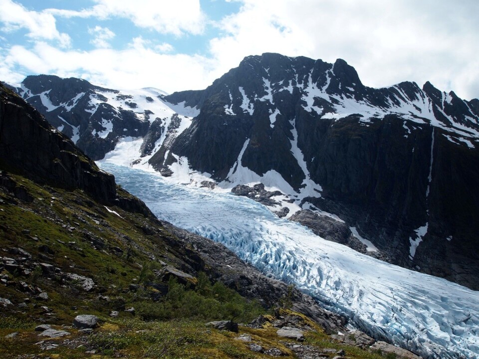
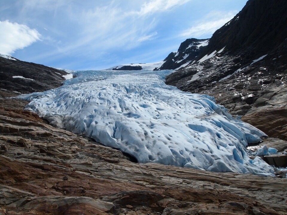
The view from the helicopter over Engabreen, an outlet glacier of the Svartisen ice cap in northern Norway, is simply jaw-dropping. Flanked by jagged mountains, the heavily crevassed glacier tongue streams down from its source area on the high, upland plateau into a wide, lake-filled valley at the head of Holandsfjord. And somewhere hidden beneath the ice masses lies the Svartisen Subglacial Laboratory, a unique glaciological research facility located in a tunnel system under 200 metres of sheer glacier ice.
Here, I am joining Dr Miriam Jackson and Hallgeir Elvehøy from the Norwegian Water Resources and Energy Directorate (NVE) for two days in June 2016 to carry out essential maintenance fieldwork both below ground in the subglacial lab and above ground on the glacier surface of Engabreen.
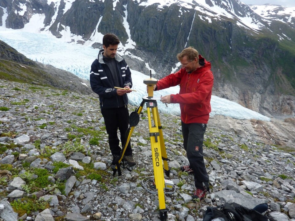
Our helicopter touches down on a small, level patch of glacier surface. Outfitted with crampons and an ice axe, Hallgeir jumps onto the ice to take measurements of one of the mass balance stakes of Engabreen, at the first of several stakes that were set out by NVE across the glacier to monitor its mass balance and movement. By measuring the height of the stake and comparing it with previous measurements, he can calculate the glacier’s mass balance.
Next, using a high-accuracy differential GPS device, he can determine the ice flow velocity at the glacier surface by recording the exact position of the stakes and how this position changes over time as the glacier (along with the stakes that are embedded in its surface) moves downhill under the force of gravity. These measurements are performed several times a year, Hallgeir explains, and can then be used to compute the mass balance and movement of Engabreen over different measurement periods, for instance, annual or seasonal. These data are crucial to understanding Engabreen’s behaviour.
With Hallgeir back on board, the helicopter lifts thunderously up into the air again, speeding over the rugged icescape with its dramatic icefalls and house-sized seracs, off to the next measurement stake further up-glacier. Not all stakes can be visited during a single fieldwork trip, however, which makes several visits during one measurement year necessary. Some of the stakes we are visiting today have melted out of the ice surface, and Hallgeir has to replace them to carry out his measurements. Maintaining this extensive network of mass balance stakes and velocity markers in this ever-changing ice world is, even though challenging and labour-intensive, one of the reasons that makes these short field visits so important.
Today’s last stake lies in the upper part of Engabreen where its ice masses flow out from the vast, ice cap on top of the mountain plateau. Up here, the glacier is blanketed in thick snow. Once again Hallgeir jumps out of the helicopter onto the smooth, snow-covered glacier surface to record the position of the stake. With its rotors spinning furiously, the helicopter is patiently waiting for Hallgeir to finish his GPS readings before lifting us off the glacier and taking us to the entrance to the subglacial laboratory.
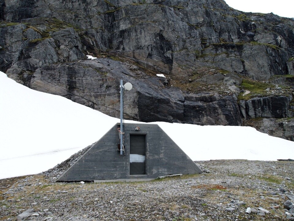
The tunnel entrance is perched high on the valley side, overlooking the lower part of Engabreen as it winds its way down from the plateau. Our pilot brings us down right next to the tunnel’s access door, which proves to be a convenient landing spot as we unload the heavy equipment that is needed for Hallgeir’s next series of measurements. From our vantage point on the mountainside, he is going to scan the glacier tongue down in the valley with a terrestrial 3D laser scanner. The scans will give a digital model of the exact geometry and surface height of Engabreen. When compared with previous elevation measurements, the model can reveal how much thinning has occurred across Engabreen’s surface.
The scanner weighs almost 15 kilogrammes and comes in a massive steel box that we have to carry back and forth across the mountainside so Hallgeir can scan the glacier from different angles. It is late in the afternoon when the final laser beam hits the glacier and we can pack up and finally enter the tunnel.
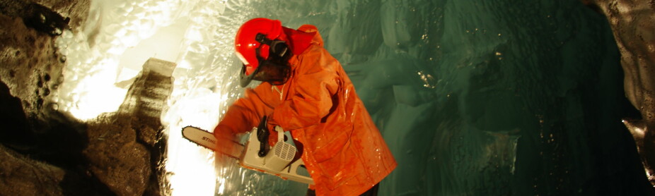
As we cross the threshold, we feel the chilly air escaping from the dark tunnel ahead that leads into the depths of the mountain. The first stretch of tunnel is not much more than a narrow, tube-shaped access passageway, and we have to switch on headlamps while our eyes are trying to adjust to the sudden darkness. But after just a short distance the access passage opens into a spacious underground gallery as wide and high as a road tunnel. From here, it is a 1.5-kilometre walk through the mountain until the tunnel reaches the lab facilities at a point somewhere directly under the central part of Engabreen.
The tunnel is dimly lit. Water is dripping from the ceiling or trickling down the rock walls. After about 300 metres, we arrive at the lab’s living quarters, which are set in a deep recess in the tunnel wall. Several living containers form a two-storey bunkhouse that provides simple accommodation with a small kitchen/common room, bathroom facilities and a handful of bedrooms. A separate container in front of the building serves as a rescue chamber and has its own emergency oxygen supply. I have a quick look around and pick a room for the night, before Miriam takes me up to the lab.

The deeper we venture into the mountain, the louder grows the sound of rushing water around us. At two or three points, side tunnels branch off the main gallery, and as we pass them, the rushing seems to swell to a thundering.
The side tunnels are all sealed off, but Miriam leads me through an access door into one of them. It is pitch-black. The only light source here are our headlamps that illuminate the ice-covered tunnel floor and walls. Our breath condenses into a misty haze in the cold air. We slowly grope our way along the walls, careful not to slip on the icy tunnel floor, until we are suddenly standing on the banks of a wild and turbulent underground river.
The torrential waters reveal the main purpose of Engabreen’s tunnel system. In 1987, the Norwegian parliament approved plans to exploit Svartisen’s watercourses for hydroelectric power generation. In the following 16 years, a vast and elaborate network of water intakes and tunnels was constructed around and beneath the ice cap, capturing its meltwaters and routing them towards the Storglomvatnet reservoir and the Svartisen Hydroelectric Power Station. The construction of subglacial water intakes under Engabreen as part of this large-scale hydropower development provided an ideal opportunity for a permanent glaciological research lab with direct access to the underside of the glacier.
Back in the main tunnel, Miriam and I continue our subterranean walk until we finally reach the lab facilities deep below the surface. The scene in front of us feels a bit like stepping into the secret lair of a James Bond villain. There are heavy equipment vehicles to maintain the tunnel network. An underground personnel carrier is parked along the tunnel side, as if waiting to transport the minions of this evil mastermind to wherever they are needed next. A group of construction site containers houses geophysical and geochemical lab equipment as well as a small data centre with PCs and flickering computer screens, as if ready to launch a destructive weapon at a major world capital.
The computers receive and store the data of numerous sensors that are embedded in the rock bed beneath the glacier. These load cells measure the pressure at the base of Engabreen, which allows inferences to be made about the subglacial drainage system and the way meltwater flows and is routed along the underside of the glacier. Since the first sensors were installed in 1992, they have produced a more than 25-year long record of subglacial pressure variations, Miriam tells me. She is the lab’s manager, and one of her responsibilities is to regularly download the data from the computers so they can be taken to NVE for further processing and analysis. The measurements have given unique insights into the processes and dynamics at work below Engabreen—insights that can be applied to comparable ice masses worldwide.
The glacier bed itself can be accessed only during winter when little meltwater is present below the glacier. Miriam shows me the two research shafts that connect the tunnel system to the base of Engabreen. The shafts are located a little further down the tunnel behind a high flood wall that separates the main tunnel with the lab buildings from the conduit carrying subglacial waters to the Storglomvatnet reservoir. I follow Miriam over the wall and up one of the research shafts, where we stand in front of a door-sized opening sealed with heavy steel bars. To access the underside of Engabreen during winter, the bars would be removed and a powerful hot water hose be used to melt a cavity into the glacier base. Today’s visit, however, ends here, with only centimetres of steel between us and the glacier.
On the next day, Miriam and Hallgeir are out on the glacier surface again installing new mass balance poles. This gives me the chance to explore the valley between the glacier margin and the fjord. About 250 years ago, during the so-called Little Ice Age, Engabreen extended all the way down to the shore of the Holandsfjord. Large arc-shaped moraine ridges mark this maximum position. Since then, the glacier has retreated more than 2.5 kilometres, and its meltwaters have formed the Engabrevatn lake. The retreat has been particularly rapid between the 1930s and 1970s and again since the beginning of the 21st century. Engabreen’s annual mass balance, which shows how much ice the glacier has lost or gained, has been negative in 11 out of the last 17 years. Nevertheless, Engabreen is still an impressive ice mass. Against the dramatic backdrop of deep glacier crevasses and towering ice pinnacles, Miriam and Hallgeir appear as two insignificant dots as they move about the blue glacier ice to put in place new measurement stakes. Being monitored from below and above ground as well as remotely from afar, Engabreen must be among the best-studied glaciers in Europe. But being kept under constant observation, the glacier also seems like a patient who requires intensive care. The subglacial sensors are like ECG electrodes recording Engabreen’s heartbeat, and the mass balance stakes and the 3D laser scanner are like medical scales measuring Engabreen’s recent weight loss. Miriam and Hallgeir will continue to monitor these symptoms. The data they collect will be useful to help better understand Engabreen’s current behaviour and possibly even predict its dynamics in the future.