Bárðarbunga-Nornahraun-utbruddet på Island gir god innsikt i magmatransport i riftsonene
Denne artikkelen er over ti år gammel og kan inneholde utdatert informasjon.
The Bárðarbunga-Nornahraun eruption - an ongoing demonstration of rifting and volcanism
The basaltic lava emission from a fissure system connected to the the Bárðarbunga central volcano under Vatnajökull is now the largest eruption in Iceland in the past 230 years. Although the central volcano is located in the Eastern Rift Zone, the erupting fissure system protrudes into the fissure swarm of the Askja central volcano in the Northern Rift Zone. The extensive arrays of seismometers and continuously recording GPS-stations have provided real-time seismic and geodetic data, illustrating the subsidence of the central volcano and associated dike injection. Additional observations and measurements on the ground and during frequent overflights with the Icelandic Coast Guard aircraft have yielded unique and complementary insights into these processes.
Notes
The developing lava field is commonly referred to as Holuhraun, which is also the name of a lava flow from 1797. In this article, I adopt the term Nornahraun, as suggested by Þorvaldur Þórðarson: http://earthice.hi.is/names_new_lava_flow_field_north_dyngjujokull
The account of the tectonic and volcanic events are mainly based on the continuously updated information on: http://en.vedur.is/ and http://en.vedur.is/earthquakes-and-volcanism/articles/nr/2947
The article is also available at: http://folk.uio.no/rtronnes/Publ-pop-sci/Vulk-jordskjelv/Bardarb-2014.pdf

Rift zones and volcanic systems in Iceland
The volcanic rift and flank zones in Iceland have separate volcanic systems, comprising central volcanoes and fissure swarms (Fig. 1). Many of the evolved central volcanoes have calderas and some of these erupt intermediate and silica-rich magmas, including rhyolites with about 70 weight% SiO2, in addition to basalts. A caldera is a sub-circular depression, normally 2-10 km in diameter, formed by magma chamber pressure loss and collapse resulting from a volcanic eruption or from injection of melt into dikes away from the caldera region. The term dike is used to describe an open fissure (often 1-10 m wide) filled with melt.
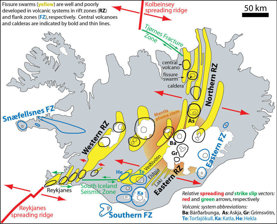
Long distance sub-surface transport of magma in dikes is a common feature associated with fissure eruptions in the rift zones. The previous three largest eruptions in Bárðarbunga involved basaltic magma transport about 100 km southwestwards from the central volcano along dikes in the Veiðivötn fissure swarm (Fig. 1), leading to fissure eruptions on the way. Some of the magma, however, was ultimately injected into silica-rich magma chambers under the Torfajökull central volcano (Fig. 1), causing explosive mixed magma eruptions. Each of these three events, the Veiðivötn, Vatnaöldur and Dómadalshraun eruptions in 1477, 871 and about 150 AD, respectively, produced about 1 km3 dense rock equivalent (DRE) of combined basaltic, intermediate and rhyolitic lava and tephra (Larsen, 1984). The 721 (approximately) and 606 year intervals between these eruptions are slightly longer than the 531 year period between the 1477 and 2014 events involving magma from Bárðarbunga.
Several other volcanic systems in the Icelandic rift zones are also characterized by interaction between silica-rich (rhyolitic) magma in shallow chambers under the central volcanoes and deeper basaltic reservoirs and dikes with basaltic melt. The puncturing of rhyolitic magma chambers by dike injection and the mixing of hot basaltic melt (1150-1200 °C) with cooler rhyolite (800 °C) can cause vigorous convection and gas (steam) bubble formation. The relatively viscous rhyolite melt may then be transformed explosively to low-density foam, fragmented and erupted as silicic ash and pumice. This process is analogous to the violent exsolution (release) of CO2-gas from shaken and depressurized champagne or beer.
Status and volume of the eruption (Nov. 6, 2014)
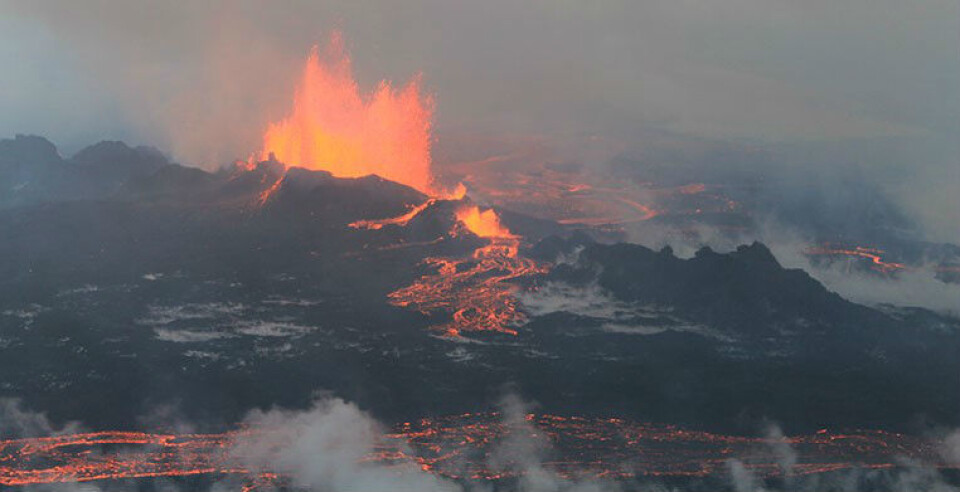
The vigorous and steady extrusion of basalt from a 2 km long crater row 45 km NE of the Bárðarbunga central volcano now seems to be the largest Icelandic eruption in the last 230 years. Starting in the early morning of Sunday, August 31, it has lasted more than two months. Fig. 2 shows the eruptive activity on Sept. 4, at an early stage before much of the magma was channelized through shallow, but covered, lava tubes.

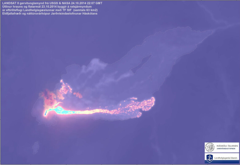
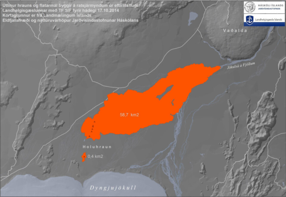
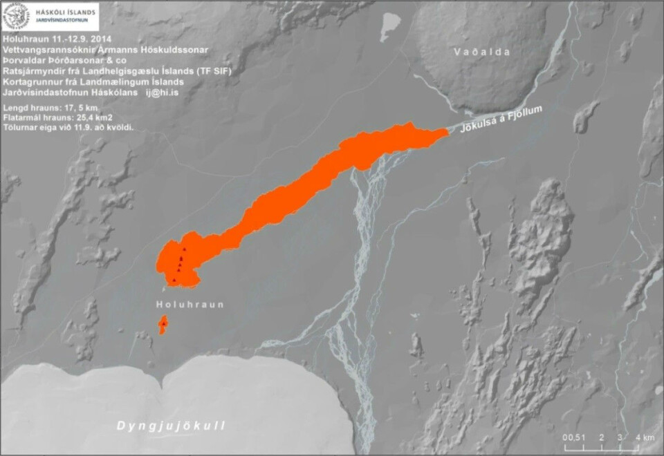
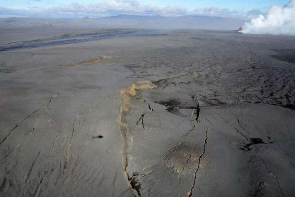
The area of the current lava field exceeds 65 km2. Initially, the lava flowed about 17.5 km towards ENE, parallel to the river Jökulsá á Fjöllum. It then stopped near the foothills of the interglacial Vaðalda shield volcano and spread towards NW and SE after Sept. 12 (Fig. 3-4). A small satellite lava field (0.4 km2) was also produced from a 1 km long eruption fissure about 2 km SSW of the constantly erupting fissure (crater row) during a three-day period, Sept. 5-7.
The volume estimates are uncertain due to the difficult observing conditions in the most remote and climatically hostile area in Iceland. Field work is also hindered by highly variable winds and unpredictable concentrations of toxic volcanic gases. Based on the unwavering observation efforts by scientists at the Icelandic Meteorological Office (Veðurstofa Íslands) and Institute of Earth Sciences, University of Iceland (Jarðvísindastofnun, Háskólans), however, it seems that the eruption has a daily magma output of about 0.02 km3.
The resulting accumulated volume of 1.4 km3 (Nov. 8) has exceeded the total outputs of the Krafla fires, 1975-84 (0.25 km3), the Myvatn fires, 1727-29 (0.25 km3) and the eruptions from Hekla-1970 (0.5 km3), Hekla-1947-48 (0.88 km3), Surtsey-1963-67 (0.73 km3), Katla-1918 (1.0 km3) and Askja-Sveinagjá-1875 (0.5 km3). The largest historic eruptions, including Laki (1783-84, 15.1 km3), Eldgjá (934-940, 19.6 km3) and Hallmundarhraun (about 950, 8.5 km3) are still about an order of magnitude larger. However, if the Nornahraun eruption continues at the current rate, the volume may surpass that of the Hekla-1766 (1.5 km3) and the Öræfajökull-1362 (2 km3) eruptions by November 13 and December 9, respectively. By then the Nornahraun eruption would be the fourth largest Icelanic eruption in historic times (after 871 AD). [The volumes above, compiled from Sinton et al. (2005), Þórðarson and Larsen (2008), Þórðarson and Höskuldsson (2008) and references therein, are combined lava and dense rock equivalents of tephra.]
Dike injection and rifting
The 2014 volcanic unrest with rifting, dike injection and fissure eruption has been monitored by dense networks of seismometers and continuously recording GPS-stations. The surveillance has given unprecedented insights into the fracturing and melt injection processes and the interaction between a central volcano and fissure swarms in the Icelandic rift zones (Fig. 5).
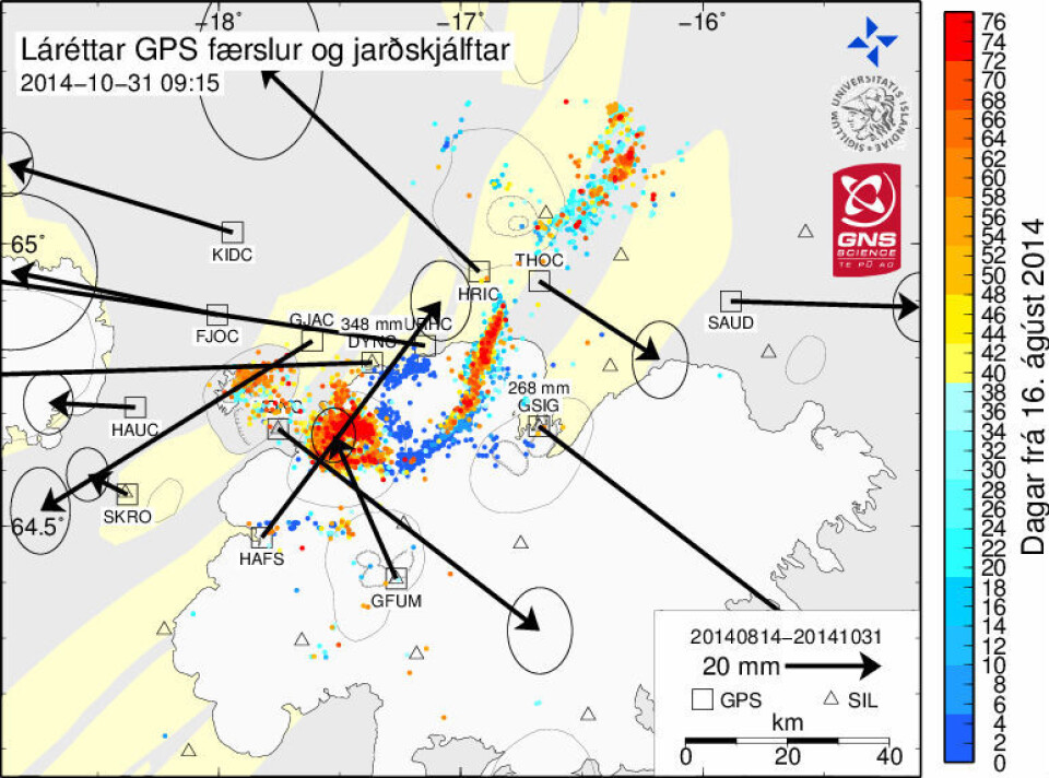
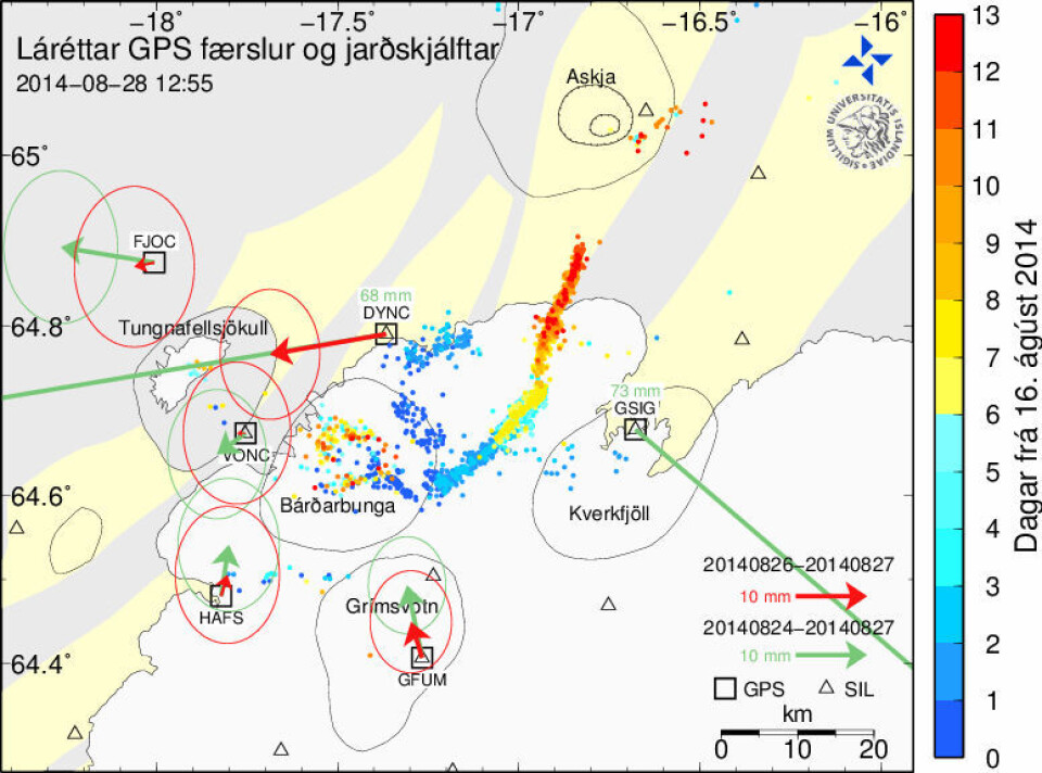
The day-to-day evolution of seismicity and horizontal crustal movements is compiled at: http://en.vedur.is/earthquakes-and-volcanism/articles/nr/2949 (including an animated evolution map and http://hraun.vedur.is/ja/Bardarb/GPS/Slider/images.html#). The rifting and volcanic unrest started on August 16, with intense seismic activity within the Bárðarbunga caldera and along an 8 km long SE-trending radial dike from the SE side of the caldera rim (Fig. 5). There was also strong seismic activity along the E and NE margin of the central volcano the same day. During the next few days (Aug. 17-19) the earthquake swarms defined a dike segment propagating 22 km towards NE (N45°E) from the SE tip of the radial dike. In the Aug 23-28 period, the dike propagation changed direction about 20° to a NNE-direction (N15°E). The magma moved another 20 km in the NNE direction before a minor, four hour long, fissure eruption occurred near the dike tip in the early hours of Friday, Aug. 29.
The intrusion of the radial dike towards SE on Aug. 16 was accompanied by displacement southwards for stations HAFS and GFUM, northwards for DYNC and eastwards for the stations west of the caldera (not visible in the 13 day accumulated motion on Fig. 5, upper panel, but on the Aug. 16 map at http://hraun.vedur.is/ja/Bardarb/GPS/Slider/images.html#). The further dike propagation towards NE and NNE involved spreading between the continuously measuring GPS-stations DYNC and GSIG of 4-6 cm/day (50-70 cm in the 12 day period, see the daily maps of seismicity and horizontal crustal movements). DYNC and GSIG are about 20 km west and 15 km east of the dike, respectively. The stations FJOC, KIDC and HAUC 30-40 km west of DYNC show only minor westward movement, demonstrating crustal compression between the dike and FJOC. The dike itself, and therefore the local rifting, is likely to be about one order of magnitude larger than the separation measured at distances of 15-20 km.
South of the Bárðarbunga central volcano, the stations HAFS and GFUM were (and are still) moving northwards, in response to the decrease in magma pressure under the caldera and inward movement of the surrounding area (Fig 5, lower panel). Because the Icelandic plate-spreading direction is approximately WNW-ESE, the southerly components affecting DYNC and GSIG (WSW and SE movement, respectively) is a result of the subsidence and contraction of the Bárðarbunga central volcano.
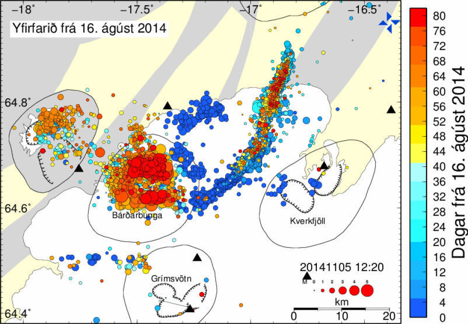
The seismic activity related to dike injection and caldera subsidence has involved 500-800 events/day. The largest events with moment magnitude up to about 5.7 have been confined to the caldera ring fault (caldera rim). In the first month of activity, the number of recorded events exceeded 20000. Even if the number has been lower during the second month of activity, the occurrence of earthquakes exceeding magnitude 5 is still common in the Bárðarbunga caldera. In addition to all the seismic activity, a minor subglacial eruption occurred on the SE flank of the volcano on August 23, probably from the earliest radial dike.
The strong and persistent (until today) seismicity along the ring faults of the caldera is accompanied by extensive subsidence of the caldera floor. On Oct. 6, 18, 25 and Nov. 6 the levels of subsidence were reported as 30, 35, 40 and 44 m, respectively, with concentrated in the NW part of the caldera. With a caldera area of about 60 km2 (long and short diameters of about 10.5 and 7 km), an average subsidence of the entire caldera floor of 44 m would represent a volume of 2.6 km3, about twice the erupted lava volume. The observed differential subsidence, however, may correspond to a volume of only 1.2 km3.
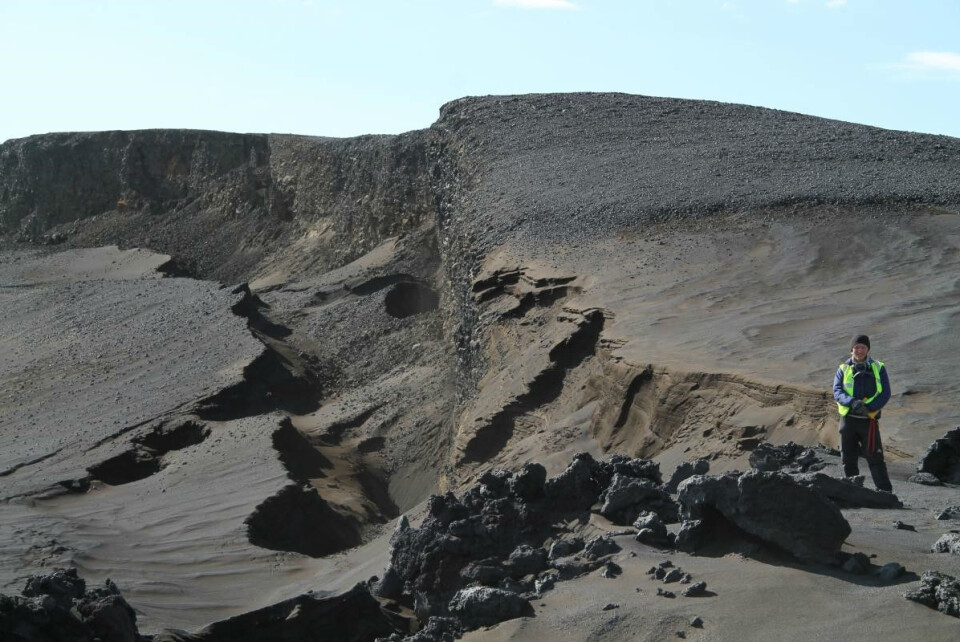
The large E-W extension NE of Bárðarbunga resulted in the formation of a 600-800 m wide and 6 km long graben partly under and partly NNE of the northern part of the Vatnajökull ice cap (Dyngjujökull) just before Sept. 5 (Fig. 6-8). As shown in Fig. 8, the small satellite eruption fissure and the corresponding lava field are within this graben. The projection of the graben trend towards NNE coincides with the continuously erupting crater row.
The 2014 eruption and rifting – regional perspectives and outlook
The Bárðarbunga volcanic system is one of the most productive systems in post-glacial (Holocene) time. The early Holocene Þjórsáhraun (about about 25 km3), fed from craters in the Veiðivötn fissure swarm, is largest post-glacial lava unit in Iceland, exceeding the historic Eldgjá (19.6 km3) and Laki (15.1 km3) lava flows from the Katla and Grimsvötn central volcanoes (Fig. 1, Þórðarson and Höskuldsson, 2008). The Bárðarbunga central volcano is close to the vertical axis of the Iceland mantle plume, which is responsible for the strongly elevated volcanic productivity in the NE Atlantic (Fig. 1, Þórðarson and Höskuldsson, 2008, Jones et al. 2014). Currently, the high rate of mass loss due to the melting of the Vatnajökull glacier (Björnsson and Pálsson, 2008) also leads to increased decompression melting of the mantle under central Iceland (Sigmundsson et al. 2014).
The large mixed-magma eruptions originating from Bárðarbunga in 1477, 871 and about 150 AD started with dike injection about 100 km southwestwards along the Veiðivötn fissure swarm, causing reactions between the injected basaltic magma and the rhyolite melt under the Torfajökull central volcano. The 2014 eruption differs from this pattern in the sense that the basaltic dike injection is towards NE from Bárðarbunga. The sequential propagation of three dike segments from the caldera (Fig. 5, upper panel) prior to the first fissure eruption near the dike tip on Aug. 29, demonstrates that magma was injected from a NE-trending dike swarm in the Eastern Rift Zone to a NNE-trending dike swarm originally belonging to the Askja volcanic system in the Northern Rift Zone (Guðmundsson et al. 2014). The general change in directions of the fissure swarms at the latitude of central Iceland (64.5 to 65 °N) is present also in the Tertiary lavas plateaus in east Iceland. Therefore, it seems that the stress field and spreading geometry has been approximately stationary during the last 10 Ma (Guðmundsson et al. 2014).
It is difficult to predict how the eruption will evolve and how long it will last. The relatively constant rate of eruption during the first two months is remarkable and could indicate further extension of the eruption period. The magma conduit from the Bárðarbunga central volcano seems well established and the magma supply is closely tied to the deflation of the magma reservoir and subsidence of the caldera floor. The most likely scenario at this mature stage is that the magma supply from the deflating reservoir will decrease and finally end the eruption. Other scenarios, involving opening of new eruptive fissures to the SW or NE, as well as more extensive eruption activity in in the Bárðarbunga central volcano, possibly of explosive character, are less likely.
The societal and environmental impacts of this effusive basalt eruption are moderate, because the location in a very remote area of Iceland. Sulphuric gases, however, have created volcanic haze conditions in E and NE Iceland, as well as in the capital area. People with respiratory problems have been most affected. Satellite measurements have also detected elevated SO2 trails as far as 1500-2000 km from Iceland.
References:
Björnsson and Pálsson, 2008: Icelandic glaciers. Jökull 58, 365-386
Guðmundsson et al., 2014: Dike emplacement at Bardarbunga, Iceland, induces unusual stress changes, caldera deformation, and earthquakes. Bull. Volcanol. 76, DOI 10.1007/s00445-014-0869-8
Jóhannesson and Sæmundsson, 1998: Geological map of Iceland, 1:500.000. Tectonics. Icelandic Institute of Natural History and Iceland Geodetic Survey, Reykjavík
Larsen, 1984: Recent volcanic history of the Veidivötn fissure swarm, southern Iceland – an approach to volcanic risk assessment. J. Volcanol. Geotherm. Res. 22, 33–58
Þórðarson and Larsen, 2007: Volcanism in Iceland in historical time: Volcano types, eruption styles and eruptive history. J. Geodyn., 43, 1, 118–152
Þórðarson and Höskuldsson, 2008: Postglacial volcanism in Iceland. Jökull 58, 197-228
Sigmundsson et al., 2010: Climate effects on volcanism: influence on magmatic systems of loading and unloading from ice mass variations, with examples from Iceland. Phil. Trans. R. Soc. 368, 2519-2534
Sinton et al., 2005: Postglacial eruptive history of the Western Volcanic Zone, Iceland. Geochem. Geophys. Geosyst. 6 (12), Q12009, doi:10.1029/2005GC001021